The NetEye Geo Map Visualizer
The NetEye Geo Map module allows you to overlay the position and status of hosts on top of a customizable map based on OpenStreetMap. You can access Geo Map by clicking on the “Geo Map” menu item to the left.
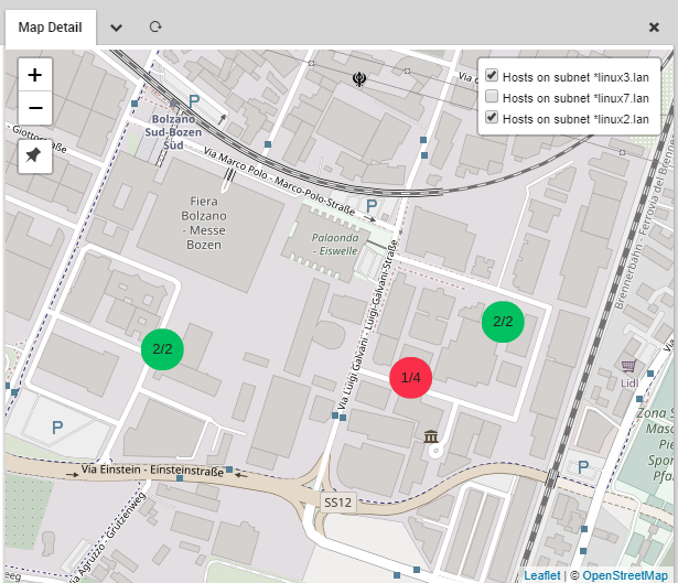
A Geo Map map.
Geo Map Features
Geo Map uses a standard map interface that allows you to zoom in and out of your chosen map. On each map you can place map markers corresponding to hosts or groups of hosts, where the color of the marker reflects the current status of the monitored objects, adopting the same colors of the monitoring modules. Alternatively, markers can be configured to display the status of a host’s services rather than the host status itself.
When multiple markers are placed at the same location, e.g. a server room, the marker will show the worst status of all hosts or services included in that marker. Clicking on a marker will launch a panel containing information on all hosts represented by that marker.
Hosts are assigned to map layers as elements of a host group. Each layer can be enabled and disabled via the map interface. You can optionally save any map as a dashlet on the NetEye dashboard, including multiple dashlets of the same map each having different layers enabled.
The Geo Map module is fully integrated with Lampo search and IcingaWeb2 Global search. With both search tools you can query for map names and find results both for map configuration and the map itself.
By default it is integrated with Audit Log module, which means that every change done in the module configuration is logged and tracked into the Audit Log section (see Auditlog user guide). If the Audit Log module is not installed this feature is disabled. Following, the list of the tracked actions:
Map create, modify and delete.
Layer create, modify, delete and sorting.
Field list modify and sorting.
Module configuration modify.
The Geo Map module also allows you to add map plugins that are compatible with the Leaflet JavaScript library.